Course Maps
2017 NT ConocoPhillips City2Surf Course Maps
The courses for the NT ConocoPhillips City2Surf 12km and 4km can be seen below. For participant safety, there will be controlled road closures. At all times, there will be at least one lane closed to traffic to make it safe for for everyone involved. Over 50 traffic marshalls and police will be utilised as safety is paramount.
12km Course - 7:00am start
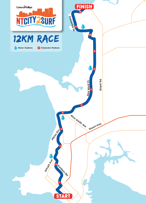
Starting on the Esplanade out side Double Tree by Hilton, the 12km run heads towards Daly Street;
Taking a right turn at the round about at the end of the Esplanade, participants then follow Daly Street until a left turn at Gardens Road;
Participants follow Gardens Road until Gilruth Avenue where they cross both lanes onto Maria Liveris Drive;
Participants follow Maria Liveris Drive up ‘Darwin High Hill’, before taking a right turn onto Atkins Road, then staying on Atkins through the round about, and down the hill towards Conacher Street;
Once through the Conacher / Atkins intersection, participants take a slight right onto the pathway weaving past Vesty’s Lake;
Where the pathway meets East Point Road, participants take a left turn, remaining on the path before returning to the road just prior to the entrance to the Sailing Club (Atkins Road);
Participants stay on East Point Road through Fannie Bay, past the Cool Spot;
At the Ross Smith Intersection, East Point Road turns into Dickward Drive, and participants stay on the road heading towards Nightcliff;
Participants are to keep to Dickward Drive through Coconut Grove. Just past the Woolworths entrance, participants will be ushered onto the footpath for a short section, as you turn left onto Progress Drive.
Participants re-enter the road just past Bouganvilia Street, following Progress Drive as it turns into Casuarina Drive along the Nightcliff foreshore;
At the beginning of the Nightcliff foreshore path, you will see a drink station and the 4km turn. Here you join the Nightcliff running/cycling path all the way to the finish at the Nightcliff Pool.
4km Course Map - 7:15am start
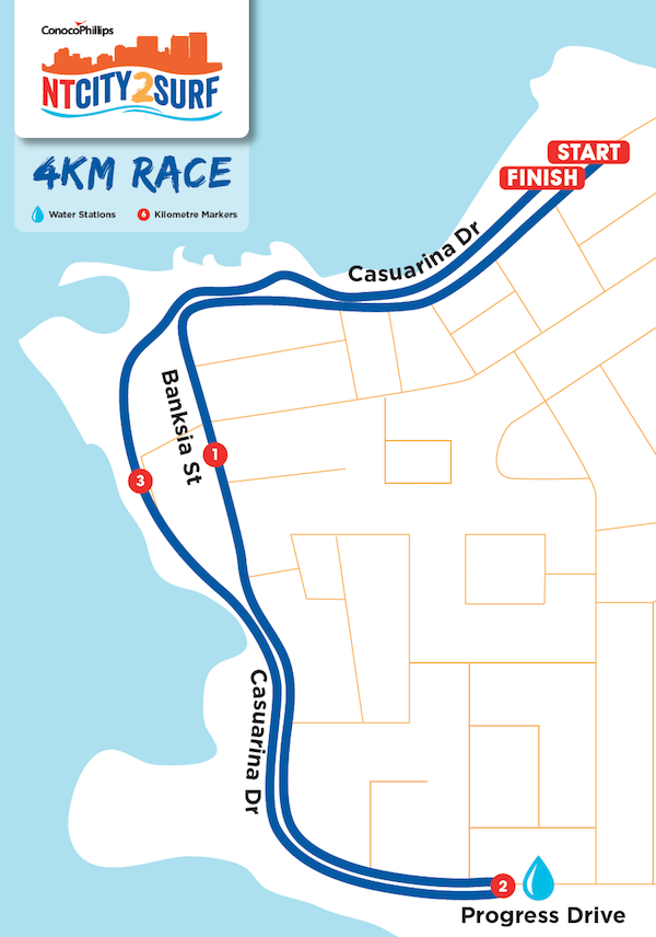
Starting parallel to the Nightcliff Aquatic Centre on the road (Casuarina Drive), participants will run/walk along the road for 2km back towards the Nightcliff Shopping Centre / Progress Drive;
The 2km turn around point is at Bouganvilia Street, just before Ten Pin Bowling;
Participants will make a 180 degree turn past the drink station and head back towards the Nightcliff pool via the pedestrian and cycle path way before crossing the finish line.